Rodosto Teknoloji: CBS yazılımı ve ArcGIS danışmanlığı.
Rodosto Teknoloji, İzmit merkezli bir CBS yazılım ve danışmanlık şirketidir. Esri Partner Network üyesi olarak belediyeler, kamu kurumları ve şirketler için ArcGIS tabanlı kurumsal CBS platformları kuruyoruz.
Kurumunuza uygun yoldan başlayın.
CBS danışmanlığından yazılım geliştirmeye, tek ekip.
Kurumsal CBS projelerinin tüm aşamalarını aynı mühendislik ekibi yürütür: strateji ve veri modeli, ArcGIS Enterprise kurulumu, sistem entegrasyonu ve kuruma özel CBS yazılımı.
Kurumların CBS ile çözdüğü işler.
Kent bilgi sisteminden şebeke yönetimine, saha operasyonundan karar destek panolarına kadar her çözüm kurumun kendi verisi ve iş akışına göre uyarlanır.
ArcGIS için geliştirdiğimiz kurumsal ürünler.
PTM ve PCM, ArcGIS Enterprise ve ArcGIS Online kullanan kurumlar için şirket içinde geliştirdiğimiz ürünlerdir. İkisi de Esri Partner Network ürün kataloğunda yer alır.
Proxy Token Manager
ArcGIS Enterprise önünde çalışan bir API gateway. Tüketici bazlı token yönetimi, IP ve referrer izin listeleri, hız sınırlama ve eksiksiz denetim kaydıyla güvenli paydaş erişimi.
Ürünü inceleyin PCM · Portal YönetimiPortal Content Manager
ArcGIS portalınızı tarar; metaveri düzeltmeleri önerir, sahipsiz içeriği ve adlandırma sorunlarını bulur, klasörleri düzenler. Tüm işlemler operatör onayıyla ilerler.
Ürünü inceleyinHaritanın kritik olduğu her yerdeyiz.
Belediyelerden altyapı kuruluşlarına ve özel sektöre kadar mekânsal altyapı, karar mekanizmalarını güçlendirir.
Kent planlamadan ruhsat takibine ve saha operasyonlarına kadar belediyelerin gündelik iş akışlarını tek mekânsal platformda dijitalleştiriyoruz.
Detaylı bilgi Altyapı, Enerji ve Kamu KurumlarıŞebeke, kesinti ve varlık yönetimini SCADA entegrasyonlu mekânsal çözümlerle gerçek zamanlı yönetilebilir hâle getiriyoruz.
Detaylı bilgi Özel Sektör ve KurumsalYer seçiminden lojistik optimizasyonuna kadar konum verisini işletmeler için ölçülebilir rekabet avantajına dönüştürüyoruz.
Detaylı bilgiÇalıştığımız teknolojiler.
Rodosto Teknoloji hakkında kısa bilgiler.
Rodosto Teknoloji ne iş yapar?
Rodosto Teknoloji, İzmit merkezli bir CBS (coğrafi bilgi sistemi) yazılım ve danışmanlık şirketidir. Belediyeler, kamu kurumları, altyapı işletmecileri ve şirketler için CBS danışmanlığı, ArcGIS Enterprise kurulumu ve desteği, sistem entegrasyonu ve kuruma özel CBS yazılımı geliştirme hizmetleri verir.
Rodosto bir Esri iş ortağı mı?
Evet. Rodosto Teknoloji, Esri Partner Network üyesidir ve Esri'nin iş ortağı dizininde listelenir. Uzmanlığımız ArcGIS Online, ArcGIS Enterprise ve ArcGIS Pro üzerine kuruludur; iş ortağı olarak ArcGIS lisanslarını da sağlayabiliriz.
Hangi ürünleri geliştiriyorsunuz?
İki kurumsal ürünümüz var: ArcGIS Enterprise önünde çalışan bir API gateway olan Proxy Token Manager (PTM) ve ArcGIS portal içeriğini tarayıp düzenleyen Portal Content Manager (PCM). İkisi de şirket içinde geliştirilir ve Esri Partner Network ürün kataloğunda yer alır.
Türkiye genelinde hizmet veriyor musunuz?
Evet. Merkezimiz İzmit'tedir. Marmara bölgesindeki kurumlarla yüz yüze, Türkiye genelindeki projelerde çevrim içi ve gerektiğinde yerinde çalışıyoruz.
Rodosto adı nereden geliyor?
Rodosto, Tekirdağ'ın tarihî adıdır ve coğrafi bakış açımızı ve köklerimizi yansıtır. RODOSTO, Rodosto Teknoloji'nin marka adıdır. Şirket Aralık 2025'te Onurhan Şeremet tarafından kuruldu.
Bir CBS şirketi seçerken nelere bakılmalı?
Firmanın kullandığı platformda resmi iş ortaklığı olup olmadığına, yazılı bir çalışma yöntemi ve kabul kriterleri sunup sunmadığına, kuruma özel geliştirmelerde kaynak kod ve dokümantasyon teslimini sözleşmeye yazıp yazmadığına ve proje sonrası destek modeline bakılmalıdır. Kurum verisine erişimin nasıl yapılacağı da baştan netleşmelidir.
Rodosto Teknoloji ile Rodosto adını taşıyan diğer işletmeler aynı mı?
Hayır. Rodosto Teknoloji, İzmit merkezli bir CBS yazılım ve danışmanlık şirketidir ve RODOSTO markasını bu alanda kullanır. Tekirdağ'ın tarihî adı olan Rodosto'yu taşıyan diğer işletme ve kurumlarla bir bağlantısı yoktur.
Bir CBS projesine nasıl başlarız?
İletişim sayfasındaki formu doldurmanız ya da hello@rodostoteknoloji.com adresine yazmanız yeterli. Ön görüşmede ihtiyacınızı dinliyor, ardından kapsam, mimari ve takvimi içeren yazılı bir teknik öneri hazırlıyoruz.
Son yazılar.
ArcGIS mimarisi, kurumsal CBS ve ürünlerimiz üzerine teknik yazılar; şirketimizden haberler.
 CBS
CBS
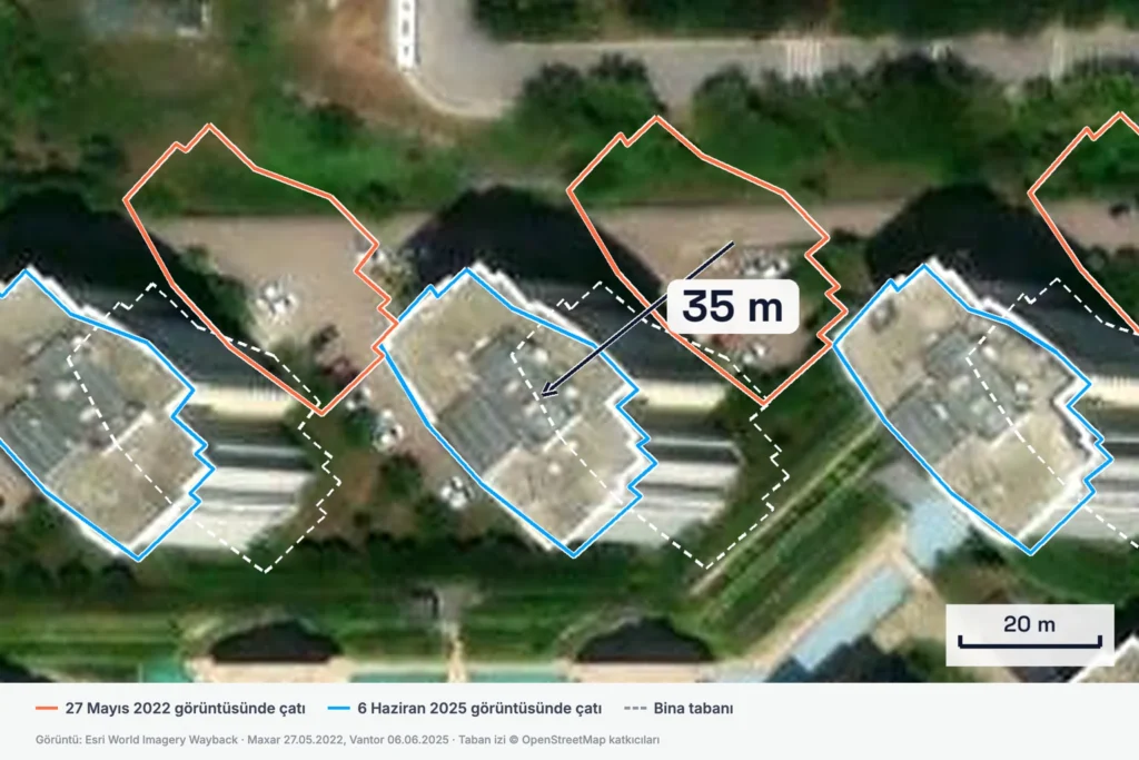
Uydu görüntüsüyle kaçak yapı tespiti: yanlış alarm veren 5 durum
22 Eki 2026
Günlük CBS işleri için ücretsiz araçlar.
Koordinat dönüştürme, rakım sorgulama ve mesafe hesaplama gibi işler için geliştirdiğimiz araçlar tarayıcıda çalışır, kayıt gerektirmez.
Projenizi konuşalım.
Kurumunuzu, verinizi ve çözmek istediğiniz konuyu kısaca anlatın. CBS mühendislerimiz talebinizi inceleyip size doğrudan döner.